Photo by Jordi Costa Tomé on Pexels
Best hikes in France: top 10 trails to walk
The path out of Chamonix before dawn smells of cold pine and diesel from the last cable car returning empty. Within thirty minutes of leaving the town centre, the valley noise drops away and the only sound is boot on gravel and the distant creak of a glacier settling. France has a way of doing this — pulling you abruptly from croissant-and-café civilisation into landscape that feels genuinely vast, genuinely demanding, genuinely indifferent to your plans.
That contrast is part of what makes France one of the best countries in Europe for long-distance walking. The trail network — the Grandes Randonnées, marked in red and white across every region — covers roughly 115,000 kilometres. It connects glaciated alpine ridges to volcanic plateaux, limestone gorges to Atlantic coastline, Mediterranean scrubland to Breton clifftops. The ten trails below span that range. They’re chosen for what they actually deliver underfoot: varied terrain, strong logistics, honest challenge, and the kind of slow encounter with a place that a car window simply doesn’t permit.
A note on format: each entry includes practical logistics, not just scenery. Difficulty ratings, access, base towns, permit requirements (where they exist), and the most useful seasonal window. France requires no hiking permits for its national long-distance trails, but some refuges require advance booking, particularly in July and August. Carry cash in smaller mountain villages — card machines are unreliable at altitude.
The 10 best hikes in France
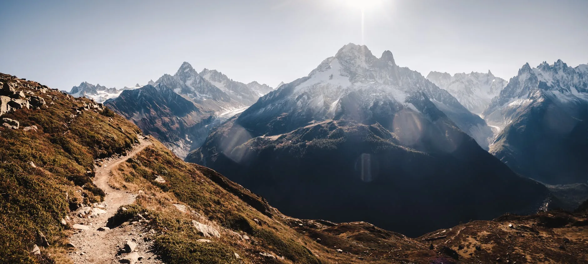
1. Tour du Mont Blanc (TMB) — Haute-Savoie / Aosta Valley / Valais
Distance: 170 km | Duration: 10–12 days | Difficulty: Moderate–Strenuous
The TMB is France’s most famous long trail, and the fame is warranted. It circumnavigates the Mont Blanc massif through three countries — France, Italy, and Switzerland — crossing eleven major passes, dropping through the Italian Val Ferret, and returning via the Swiss Val de Trient before the final descent back into Chamonix. The French sections are the most dramatic: the Col de la Croix du Bonhomme (2,479m) and the exposed ridge walk above the Aiguilles Rouges offer some of the finest high-alpine walking in Europe.
The trail is popular, particularly in July and August, when the refuges along the standard route book out months in advance. The Refuge des Mottets, Refuge Bonatti, and Refuge de la Balme are consistently good; budget €55–75 per night for half board (dinner, bed, breakfast). If you want more solitude, the Variante Chapieux on the French side sees far fewer walkers than the main route through Les Contamines.
Getting there: Train to Saint-Gervais-les-Bains–Le Fayet, then the Mont Blanc Express to Chamonix. From Paris Gare de Lyon, TGV to Saint-Gervais takes around five and a half hours. Most walkers start and finish in Chamonix.
Best season: Late June to mid-September. Snow on the high passes lingers into late June; storms become more frequent after mid-September.
2. GR20 — Corsica
Distance: 180 km | Duration: 15–16 days | Difficulty: Strenuous–Very Strenuous
Routinely described as the most demanding long-distance trail in Europe, the GR20 runs north to south through the spine of Corsica, from Calenzana (near Calvi) to Conca (south of Porto-Vecchio). The northern section is the harder half: relentless granite scrambling, fixed chains on exposed sections, minimal shelter from afternoon thunderstorms. The southern section is longer but gentler, passing through maquis-covered hillsides and high pastoral zones where Corsican shepherds still graze sheep at altitude.
The trail is divided into fifteen stages. Most walkers complete it in fifteen to seventeen days; attempting fewer than that means very long days on unforgiving terrain. The bergeries — shepherd huts converted to simple refuges — serve hot food in the evening. The bergerie at Ciottulu di i Mori and the refuge at Manganu are worth budgeting extra time around; both sit in genuinely beautiful positions. Budget €18–25 per night for a bunk in a refuge tent or dormitory, more for a private room if available.
Getting there: Fly to Calvi or take the ferry from Marseille or Nice to Calvi (Corsica Ferries). Conca is served by taxi or seasonal bus back to Porto-Vecchio, then onward transport south.
Best season: Mid-June to mid-September. The trail is frequently snowbound before late June at altitude. Avoid late July and August if possible — the refuges are at capacity and water sources dry up on the southern stages.
3. GR10 — Pyrenean Traverse (Atlantic to Mediterranean)
Distance: 866 km | Duration: 45–55 days | Difficulty: Strenuous
The GR10 follows the French side of the Pyrenees from Hendaye on the Atlantic coast to Banyuls-sur-Mer on the Mediterranean, staying almost entirely in France and dipping below the high ridges to pass through Basque, Béarnaise, and Catalan villages. It is a longer, more culturally varied trail than its wilder sibling, the HRP (see below), and is far more manageable for walkers without technical mountaineering experience.
The western Basque section between Hendaye and Saint-Jean-Pied-de-Port is green, foggy, and excellent — rolling farmland and forest with stone farmhouses and the smell of wet grass. The central section around the Parc National des Pyrénées, particularly the stages near Gavarnie and the Cirque de Troumouse, is the most spectacular. The eastern stages through Ariège and into Catalan country feel drier, rockier, and quieter. Most walkers tackle sections rather than the full traverse; the stages between Saint-Lary-Soulan and Bagnères-de-Luchon are a strong standalone week.
Getting there: Hendaye is directly connected to the Eurorail network via Bayonne. Banyuls-sur-Mer has a train station on the Perpignan–Cerbère line.
Best season: Late June to late September. The central Pyrenees carry snow on high passes until mid-June.
4. Haute Route Pyrénéenne (HRP) — High Route Pyrenees
Distance: 800 km | Duration: 45–50 days | Difficulty: Very Strenuous
The HRP is the GR10’s demanding counterpart: a high-level route that stays close to the Franco-Spanish watershed, crossing into Spain and back repeatedly, navigating passes above 2,800m, and covering terrain that is often unmarked and requires map-reading competence. There are no waymarks for long stretches. This is not a trail for walkers who rely on smartphone apps and clear signage — it demands navigation skills, experience in rapidly changing alpine weather, and a willingness to improvise.
What the HRP offers in return is something rare in Western Europe: stretches of genuinely remote walking where you can go half a day without seeing another person. The section through the Ordesa y Monte Perdido massif (crossing briefly into Spain), the high route above the Néouvielle lakes, and the traverse above the Cirque de Lescun are among the most satisfying mountain days you can find in France.
Logistics are harder than the GR10: fewer village gîtes, longer stages, and more exposed bivouac camping. Carry a solid tent; the Exped Mira III or similar ultralight three-season models work well at this altitude.
Getting there: Same endpoints as the GR10 — Hendaye and Banyuls-sur-Mer. Most walkers access the HRP via the GR10 trailhead and diverge at the first high pass.
Best season: Early July to mid-September. The high passes are serious in snow; check conditions before committing to the central stages.
5. GR5 — Alps Traverse (Lake Geneva to Nice)
Distance: 670 km | Duration: 35–40 days | Difficulty: Moderate–Strenuous
The GR5 is France’s great north-to-south alpine traverse, dropping from Lake Geneva through the Vanoise National Park, past the Écrins massif, and eventually descending through the Alpes-Maritimes to the Mediterranean at Nice. It is long, but more forgiving in logistics than either the GR20 or the HRP: well-maintained, consistently waymarked, with regular villages and a strong refuge network.
The Vanoise section is the highlight for most walkers: the stage from Modane to Val d’Isère crosses high glaciated terrain with views across to the Italian Alps, and the descent into the Maurienne valley is genuinely beautiful in late July when the alpine flowers are at their peak. The final approach to Nice — down through the Mercantour National Park and the perched villages of the Alpes-Maritimes — has a storybook quality: stone villages with lavender shutters, the smell of thyme and juniper, and the growing warmth of the south.
Getting there: Train to Geneva or Évian-les-Bains for the northern trailhead. The Nice end is well-connected by train, bus, and air.
Best season: Late June to late September.
6. Chemin de Stevenson (GR70) — Cévennes
Distance: 272 km | Duration: 12–15 days | Difficulty: Easy–Moderate
In 1878, Robert Louis Stevenson walked the 220-kilometre route through the Cévennes with a donkey named Modestine, writing it up as Travels with a Donkey in the Cévennes. The GR70 follows much of his route from Le Monastier-sur-Gazeille (in the Auvergne) to Saint-Jean-du-Gard in the Cévennes, passing through the volcanic highlands of the Velay, the chestnut forests of Lozère, and the Protestant Cévennes villages that shaped much of southern French cultural history.
This is the most culturally rich trail on this list. It’s not technically demanding — the elevation changes are manageable, the path is generally clear, and there are gîtes and chambres d’hôtes every fifteen to twenty kilometres. What makes it stand out is the quality of the landscape detail: the smell of gorse and wild thyme on the Mont Lozère plateau, the sound of bells from the herds of Aubrac cattle, the chestnut-stone villages of the Corniche des Cévennes with their slate roofs and Huguenot chapels. It’s also one of the few trails on this list where you can walk with a donkey — several outfitters in Le Pont-de-Montvert and Le Bleymard rent them for multi-day stages.
Getting there: Le Monastier-sur-Gazeille is accessible by bus from Le Puy-en-Velay, which has a train connection from Lyon. Saint-Jean-du-Gard is served by bus from Nîmes.
Best season: April to June and September to October. This route is genuinely walkable in spring and autumn — a rarity on this list.
7. Sentier des Douaniers (GR34) — Brittany Coastal Path
Distance: 1,800 km (sections walkable) | Duration: Variable | Difficulty: Easy–Moderate
The GR34 runs the entire coastline of Brittany, from Mont-Saint-Michel in the east to the border with Loire-Atlantique in the south. Named after the customs officers (douaniers) who once patrolled this coastline for smugglers, it is one of France’s most underrated long-distance trails — not because of altitude or drama, but because of what it shows you about a France that feels genuinely different from the Mediterranean or Alpine versions.
The northern Côte de Granit Rose section, between Perros-Guirec and Trébeurden, is the most photographed: enormous pink granite boulders tumble into a grey-green sea, and the path weaves between them at low tide with startling intimacy. The section around the Presqu’île de Crozon is more dramatic — Atlantic headlands with 100m cliffs above surf that sounds like distant artillery. Inland from the coast, Breton villages serve kouign-amann (a dense, caramelised butter cake from Douarnenez) and buckwheat galettes with salted butter, which tastes significantly better after fifteen kilometres of coastal wind.
Few walkers attempt the full route; a ten-day section from Saint-Brieuc to Brest covers the strongest terrain and connects to reliable SNCF rail links at both ends.
Getting there: Train from Paris Montparnasse to Rennes, then onward to Saint-Brieuc or Brest. Frequency and journey times are well-documented on the SNCF website.
Best season: May to June and September to October. July and August are fine but the campsites along the route fill fast.
8. Traverse of the Écrins — Parc National des Écrins
Distance: 180–250 km (depending on variant) | Duration: 10–14 days | Difficulty: Strenuous
The Écrins is the highest national park in France, and the least visited of the alpine parks in proportion to its size and drama. It sits south of Grenoble and east of Gap, a compact massif of glaciated peaks, moraines, and high pasture that receives a fraction of the footfall of the Mont Blanc area. The Tour de l’Oisans et des Écrins (GTOE) circles the entire massif and can be completed in ten to fourteen days; shorter sections, particularly the routes around La Bérarde and the Vallée du Vénéon, are worth two to three days alone.
The approach from La Bérarde — a tiny hamlet at the end of the D530 road in the Vénéon valley — to the Refuge du Promontoire and the glacier above it is one of the finest day walks in France. The refuge sits at 3,092m and serves hot soup and cheese platters. There are no crowds because there is no cable car, no glamour hotel, and no easy shortcut. Getting there requires either a bus from Bourg-d’Oisans (seasonal, approximately €5 one way) or a car. The village has no mobile signal and two permanent residents.
Getting there: Grenoble is connected to Paris by TGV (3 hours). Seasonal buses run from Grenoble to Bourg-d’Oisans; onward transport into the valleys is limited.
Best season: Late June to mid-September.
9. Gorges du Verdon — Sentier Martel
Distance: 14 km (one way) | Duration: 1–2 days | Difficulty: Moderate
The Gorges du Verdon is often described as Europe’s Grand Canyon — a comparison that, for once, holds up. The Verdon river has carved a canyon up to 700m deep and 25km long through the Provence limestone plateau, and the Sentier Martel is the best way to experience it from the bottom.
The trail runs the full length of the gorge interior, between the Chalet de la Maline and Point Sublime, passing through sections of near-darkness where the canyon narrows to a few metres, scrambling along fixed ladders and chains, and wading through two tunnels that require a headlamp. It is not technically difficult, but it demands attention: the path is uneven, wet in places, and the tunnels are genuinely dark and cold. The scale of the walls above you — streaked limestone, yellow and ochre, rising vertically from the turquoise river — is the kind of thing that photographs consistently fail to capture.
Logistics: this is a linear trail, so you need either two cars or pre-arranged transport between the two ends. The nearest town is Castellane to the east; the village of La Palud-sur-Verdon to the north provides accommodation including the excellent Refuge du Couloir Samson (book in advance; approximately €35 per night for a bunk). Moustiers-Sainte-Marie, one of the most atmospheric villages in Provence, is 25km west and worth an overnight.
Getting there: No direct public transport into the gorge interior. Castellane is served by seasonal bus from Digne-les-Bains (TNPCA network). A car is strongly recommended for this one.
Best season: April to June and September to October. July and August are very hot in the gorge; the trail can be dangerously slippery after heavy rain.
10. Massif Central: Tour des Volcans d’Auvergne (GR30)
Distance: 180 km | Duration: 8–10 days | Difficulty: Easy–Moderate
The Massif Central is one of the most overlooked walking destinations in France, particularly among non-French visitors. The Tour des Volcans d’Auvergne circuits the ancient volcanic terrain of the Puy-de-Dôme department, passing through the Chaîne des Puys (a UNESCO World Heritage Site since 2018) and the Monts Dore, looping around crater lakes, lava flows, and the extraordinary summit plateau of the Puy de Sancy (1,886m — the highest point in the Massif Central).
The trail is not dramatic in the alpine sense: there are no exposed ridges or glacier crossings, and the maximum elevation is modest by French standards. What it offers instead is a particular kind of open, rolling, volcanic landscape — the summits are rounded rather than jagged, the lakes sit in old calderas and reflect flat grey skies — with excellent regional food at every stop. Clermont-Ferrand, the regional capital, is an hour’s drive from most trailheads and has a TGV connection to Paris (3 hours). Expect truffade (potato and Cantal cheese, fried together) and aligot (mashed potato blended with stretched Tomme fraîche until it forms elastic, cheesy ropes) in every village restaurant. Both are exactly what you want after a day in the cold volcanic air.
Getting there: Train from Paris Gare de Lyon to Clermont-Ferrand, then regional buses or taxi to Orcival or Murol (the most convenient start points).
Best season: May to October. The Massif Central is walkable earlier in the season than the high Alps.
Comparison table: 10 best hikes in France
| Trail | Distance | Duration | Difficulty | Best Season | Permit Required | Car Needed |
|---|---|---|---|---|---|---|
| Tour du Mont Blanc | 170 km | 10–12 days | Moderate–Strenuous | June–Sept | No (refuge booking) | No |
| GR20, Corsica | 180 km | 15–16 days | Very Strenuous | Mid-June–Sept | No | No |
| GR10, Pyrenees | 866 km | 45–55 days | Strenuous | Late June–Sept | No | No |
| HRP, Pyrenees | 800 km | 45–50 days | Very Strenuous | July–Sept | No | No |
| GR5, Alps | 670 km | 35–40 days | Moderate–Strenuous | Late June–Sept | No | No |
| GR70, Cévennes | 272 km | 12–15 days | Easy–Moderate | Apr–Jun, Sept–Oct | No | No |
| GR34, Brittany | 1,800 km | Variable | Easy–Moderate | May–Jun, Sept–Oct | No | No |
| Écrins Traverse | 180–250 km | 10–14 days | Strenuous | Late June–Sept | No | Useful |
| Sentier Martel, Verdon | 14 km | 1–2 days | Moderate | Apr–Jun, Sept–Oct | No | Recommended |
| GR30, Auvergne | 180 km | 8–10 days | Easy–Moderate | May–Oct | No | No |
Planning your trip: practical logistics
Getting to France: Eurostar from London St Pancras to Paris takes two hours fifteen minutes; from Paris, the TGV network puts Chamonix, Grenoble, Nîmes, Clermont-Ferrand, and Bayonne within three to five hours by rail. For the GR20, Corsica is best reached by ferry from Marseille or Nice (Corsica Ferries and La Méridionale both run services), or by low-cost flight into Bastia or Figari.
Refuges and accommodation: Most refuges on the major routes operate on a half-board system (dinner and breakfast included). Prices range from €55–80 in the Alps to €18–30 on the GR20. Book well ahead for July and August — the Refuge de la Croix du Bonhomme on the TMB, for instance, books out in February. Websites to check: les refuges de France maintains a comprehensive, free database covering over 7,000 huts and shelters across the country.
Maps and navigation: IGN (Institut Géographique National) 1:25,000 maps are the gold standard for French trail navigation. For the full GR10 and HRP, the TopoGuides published by the FFRandonnée are indispensable. GPS tracks for most GR routes are freely available on Visorando and komoot.
Health and insurance: EU citizens can use the European Health Insurance Card (EHIC) in France. Non-EU travellers need travel insurance that explicitly covers mountain rescue and helicopter evacuation — this is non-negotiable in the Alps. PGHM (Peloton de Gendarmerie de Haute Montagne) conducts mountain rescues in France free of charge, but only when the emergency is genuine.
Food on trail: For longer multi-day trails, knowing where to resupply matters. The town of Bourg-Saint-Maurice is the best resupply point on the GR5; Gavarnie works well on the GR10; Corte on the GR20 is the major resupply town, with a supermarket and ATM. The quality of food available in French villages along most of these routes — charcuterie, cheese, bread baked that morning — is one of the genuine pleasures of walking here rather than elsewhere. The best local food markets in Europe piece on this site is worth reading before you plan your route if the cultural food side of travel matters to you.
If long trails through rugged terrain draw you generally, there are strong parallels in other mountain ranges. The structural challenges of planning a multi-day hike — logistics, accommodation, weather windows, route variants — translate directly, and the best multi-day hikes in Patagonia for beginners covers similar ground for South America’s southern cone.
The Bottom Line
-
The TMB is the easiest entry point for alpine walking in France — well-marked, well-serviced, and logistically straightforward. Book refuges in March for July travel or you’ll be making compromises.
-
The GR20 is genuinely hard. If you have not done extended mountain walking with scrambling sections, do not start the northern half without first building your legs on the GR5 or the Écrins.
-
France requires no hiking permits on any of these routes, but refuge booking is effectively mandatory in high season on the major alpine trails. This is a time-booking system, not a permit system — but treat it with the same seriousness.
-
The best hikes in France are not all in the Alps. The GR70 through the Cévennes and the GR34 along the Brittany coast offer a completely different quality of experience — slower, more cultural, more connected to French history and food — and are walkable in spring and autumn when the mountains are still under snow.
-
For the HRP and the Écrins backcountry, bring real navigation skills. A downloaded GPX track is helpful; knowing how to read a 1:25,000 contour map when the cloud drops is essential.
Keep reading: Best multi-day hikes in Patagonia for beginners