Photo by ROMAN ODINTSOV on Pexels
Volcano trekking in Indonesia: Java and Lombok
The path up Semeru begins in the dark, at around midnight, with a torch beam catching the dust of loose volcanic scree and the silhouette of the person three steps ahead. The air at 3,000 metres is cool enough to need a jacket but not cold enough to stop you sweating. Somewhere behind you, a line of headlamps stitches its way up the mountain like a slow, bright seam. This is Java’s highest peak — 3,676 metres — and it earns every step.
Indonesia sits on the Pacific Ring of Fire, and Java and Lombok between them hold some of the most accessible and dramatic active volcanoes on earth. The range is genuine: from the sulphur-stained crater of Ijen, which you can reach in a few hours with a moderate fitness level, to the grinding multi-day ascent of Rinjani, which demands real preparation and two or three full days on the mountain. The point isn’t to collect summits. It’s that each of these volcanoes opens up a different corner of Indonesian landscape, culture, and character — and the trekking is, in most cases, surprisingly accessible for anyone reasonably fit and organised.
This guide covers the four main volcanoes worth planning a trip around: Ijen and Semeru on Java, and Rinjani on Lombok, plus a note on Bromo, which is in a different category but belongs in any honest conversation about this region.
Kawah Ijen, East Java: the blue fire and the sulphur miners
Kawah Ijen sits in the Banyuwangi Regency of East Java and is genuinely unlike anything else on the trek circuit. The crater holds an acidic turquoise lake — the largest in the world by volume — and vents that produce blue sulphuric flames visible only in the dark, typically between midnight and 4am. Most visitors make the climb in the pre-dawn hours specifically to see this.
The trailhead is at Paltuding, about 17 kilometres from Licin village, which itself is around 38 kilometres from Banyuwangi town. The path to the crater rim is 3 kilometres and takes roughly 1.5 to 2 hours — steep in places but not technical. From the rim, a further descent into the crater (about 800 metres) brings you close to the lake and the sulphur vents. This section is significantly steeper and involves loose rock; a gas mask is not optional if you go down, and you can rent one at the trailhead for around 30,000–50,000 IDR (roughly USD $2–3). Bring your own if you want a better fit.
Entry permit: 100,000 IDR on weekdays, 150,000 IDR on weekends (approximately USD $6–9). A guide is not required but local guides offer their services at the trailhead for around 100,000–150,000 IDR for the return journey — worthwhile in the dark, particularly for the crater descent.
While you’re here, pay attention to the miners. Men carry loads of raw sulphur — sometimes 70–90 kg — out of the crater on bamboo poles, twice a day, for roughly 1,000 IDR per kilogram. This is not performance; it’s work. Photograph respectfully if at all.
Getting to Paltuding: From Banyuwangi, take a taxi or ojek (motorbike taxi) to Licin, then arrange a local vehicle or ojek to the Paltuding trailhead. The full journey costs around 150,000–200,000 IDR. You can also join a pre-organised morning transfer from your guesthouse in Banyuwangi, which is the easiest option and costs around 100,000 IDR per person.
Stay in: Banyuwangi town has good budget guesthouses; Arabica Homestay and several others near Jalan Ahmad Yani are well-placed and used by trekkers. Alternatively, a homestay closer to Licin puts you nearer the mountain.
Mount Bromo, East Java: the classic caldera view
Bromo (2,329 m) is not a hard trek — the crater rim is reached via a 45-minute walk across the Sea of Sand from the village of Cemoro Lawang, or by rented jeep and then a steep staircase. It is, however, one of the most visually arresting volcanic landscapes in Southeast Asia: a vast caldera with smoke rising from the active cone against a ridgeline of higher peaks including Semeru.
The famous sunrise viewpoint is at Penanjakan (2,770 m), reached by jeep from Cemoro Lawang. Jeep hire runs around 450,000–600,000 IDR for a shared vehicle; most guesthouses in Cemoro Lawang arrange these. The crowds at Penanjakan at peak season (June–August) can be thick. For a quieter alternative, the ridge at Bukit Cinta gives a similar angle with fewer people.
Bromo is the entry point for the Bromo Tengger Semeru National Park (entry fee: 220,000 IDR on weekdays, 320,000 IDR on weekends for foreign visitors). If you’re planning to also climb Semeru, this same park encompasses both.
Worth knowing: Cemoro Lawang is the base village and has a range of guesthouses and warung (small food stalls). Nasi rawon — a black beef soup using kluwek nut, common in East Java — appears on most menus here and is worth ordering.
Mount Semeru, East Java: Java’s highest point
Semeru (3,676 m) is a serious undertaking that should not be treated lightly. It is an active stratovolcano that erupts regularly from the Jonggring Seloko crater at the summit — eruptions at the very top are frequent, which is why the summit itself is officially closed to trekkers. The permitted destination is Mahameru (the peak ridge), and even this requires registering and demonstrating fitness.
The route: Most treks begin at Ranu Pani village (2,100 m), the park registration point for Semeru. The standard itinerary is two nights, three days:
– Day 1: Ranu Pani → Ranu Kumbolo (a high crater lake at 2,400 m) — approximately 4–5 hours
– Day 2: Ranu Kumbolo → Kalimati base camp (2,700 m) — 3 hours, with an optional detour to Oro-oro Ombo meadow (lavender wildflowers in season, though invasive verbena has altered the landscape in recent years)
– Day 3: Midnight summit push from Kalimati to Mahameru → return to Ranu Pani
The summit section — Kalimati to Mahameru — is 4–5 hours of steep, loose scree and volcanic sand. It is physically demanding and disorienting in the dark. Poles help.
Permits and registration: All trekkers must register at the SIMAKSI online system (simaksi.menlhk.go.id) before arrival. Foreign visitor quota is limited; slots for popular dates fill weeks or months ahead. The trekking permit costs 320,000 IDR on weekdays, 420,000 IDR on weekends, plus the national park entry fee. A mandatory registered guide must accompany all foreign trekkers — local guiding agencies in Malang and Lumajang can arrange this for around 400,000–600,000 IDR per day.
Getting to Ranu Pani: Take a bus or train to Malang (well-connected by rail from Surabaya, around 2–3 hours). From Malang, hire a private vehicle to Tumpang village, then continue by jeep or ojek to Ranu Pani. Total journey from Malang is 3–4 hours.
Gear: Temperatures at Kalimati drop below 5°C at night; the summit push before dawn can feel close to 0°C with wind chill. Sleeping bag rated to at least 0°C, insulated jacket, and rain gear are essential. Tents can be rented in Ranu Pani or through your guide agency.
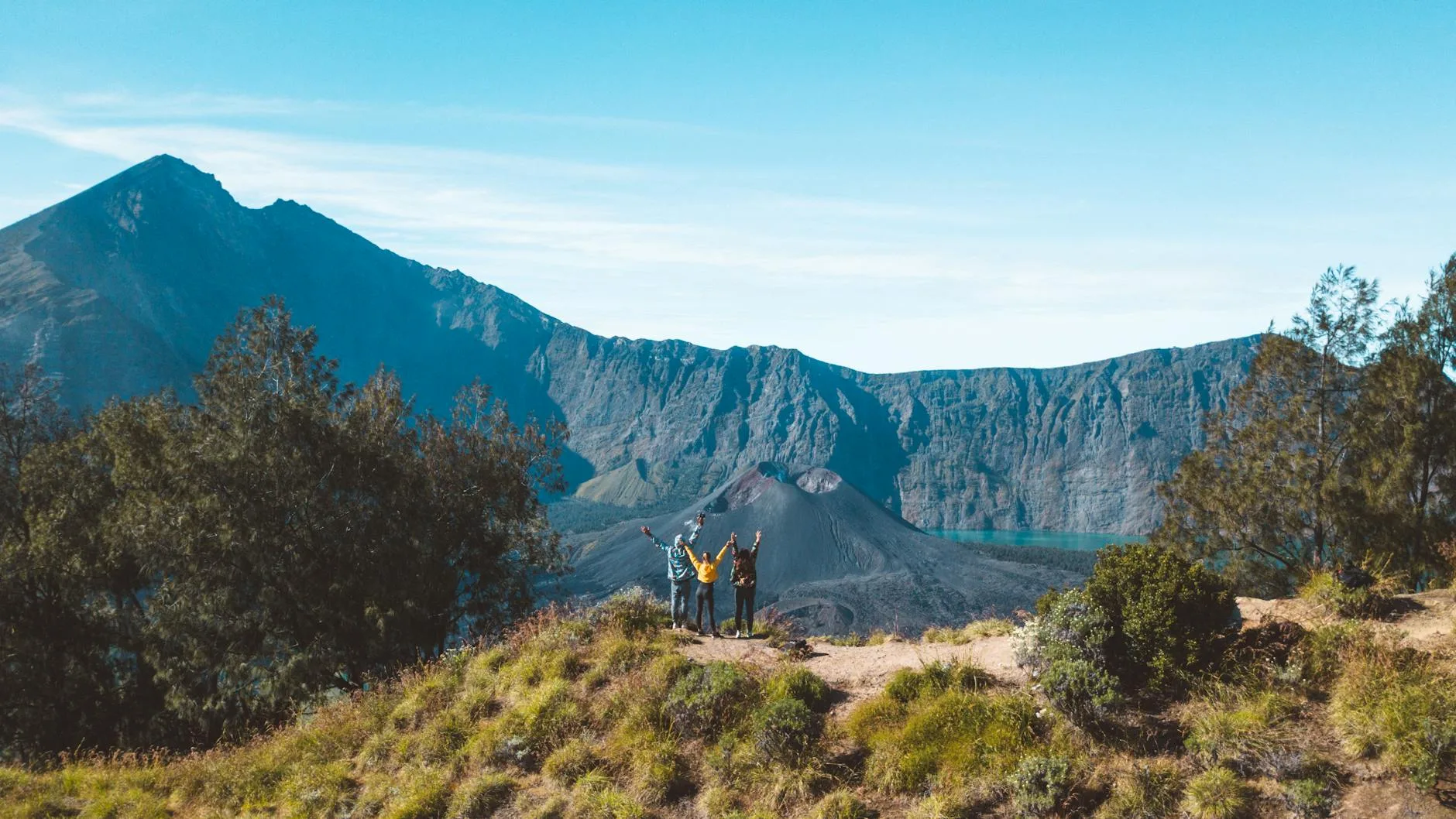
Mount Rinjani, Lombok: the island giant
Rinjani (3,726 m) is one of Indonesia’s highest peaks and among the most dramatic multi-day treks in Southeast Asia. The mountain’s interior holds a vast caldera containing Segara Anak lake (2,000 m elevation) and a young volcanic cone called Gunung Baru Jari that still steams actively. The trekking circuit here is genuinely varied: dense forest, open ridge, volcanic descent, hot springs beside the lake.
Main routes and trailheads:
| Route | Trailhead | Duration | What it covers |
|---|---|---|---|
| Summit via north | Sembalun Lawang | 3 days/2 nights | Savannah ascent, summit, crater descent |
| Crater lake via south | Senaru | 2 days/1 night | Forest trail, crater rim, lake |
| Full traverse | Sembalun → Senaru | 3–4 days | Summit + lake + hot springs + forest exit |
| Short crater rim | Senaru | 2 days/1 night | Rim only, no summit |
The full traverse from Sembalun Lawang to Senaru is the most satisfying option for trekkers with 3–4 days. Sembalun Lawang (the eastern trailhead, in a highland valley at around 1,150 m) is reached from Lombok’s capital Mataram by bemo (shared minibus) or charter vehicle — around 3 hours. Senaru (the northern trailhead, a village on Rinjani’s forested lower slopes) is about 2.5 hours from Mataram.
Permits and guides: All trekking on Rinjani is managed through Rinjani Trek Eco-Tourism Program (RTEP), a community-based initiative. A licensed guide is mandatory for all routes. Full 3-day/2-night guided treks including guide, porter, and meals typically run USD $130–180 per person in a small group (3–4 people). Solo trekking with a private guide costs more. Book through operators in Senaru or Sembalun, or through agencies in Mataram.
If you’re interested in how community-managed tourism programmes like RTEP actually function on the ground, the piece on community-based tourism examples that work gives useful context on what makes them effective.
The hot springs: At the base of Segara Anak lake, geothermal springs heat pools to around 40°C. After a steep descent, this is not a small thing. Bring sandals for the rocky approach.
Physical demand: The summit push from the crater rim campsite (around 2,600 m) to the peak involves 5–6 hours of steep scree and volcanic sand, beginning at midnight. It is the hardest single section of any trek in this guide. That said, many people of ordinary fitness complete it; the key is taking it slowly and allowing acclimatisation time.
Senaru village itself is worth time beyond the mountain. The village has traditional Sasak houses and is one of the more grounded bases in Lombok — far quieter than the beach areas of Kuta or Gili Trawangan.
Choosing your volcano: a practical comparison
| Volcano | Island | Difficulty | Duration | Summit height | Permit required | Guide required |
|---|---|---|---|---|---|---|
| Kawah Ijen | Java | Moderate | Half-day | 2,799 m (rim) | Yes | No (optional) |
| Bromo | Java | Easy | Half-day | 2,329 m | Yes | No |
| Semeru | Java | Hard | 3 days | 3,676 m | Yes (SIMAKSI) | Yes |
| Rinjani | Lombok | Hard | 3–4 days | 3,726 m | Yes (RTEP) | Yes |
When to go and what to expect
The dry season — May through September — is the standard trekking window for all four volcanoes. July and August are peak months, meaning more trekkers on trail and permits (especially for Semeru) booking out further in advance.
April and October are shoulder months: fewer crowds, trails still largely passable, with some rain possible. November through March is the wet season. Bromo remains accessible year-round, and even Ijen can be done in the wet season if you accept muddy trails and reduced visibility. Semeru and Rinjani are formally closed during the wettest months (typically January and February) due to landslide risk — check the national park status before booking.
Temperatures at altitude drop sharply at night regardless of season. Java’s volcanoes sit in a humid tropical climate, meaning daytime heat at low elevation shifts quickly to cold above 3,000 m. On Rinjani, the open savannah of the Sembalun approach offers little shade — sun protection matters as much as cold-weather gear.
Eating around the trailheads
None of these trekking areas are known for destination food, but each has its character. In Banyuwangi, look for soto Banyuwangi — a clear, coconut milk–enriched chicken soup served with steamed rice and prawn crackers — at the morning warungs near the central market, Pasar Banyuwangi. In Cemoro Lawang (Bromo), nasi rawon is everywhere, and the black soup is warming at 2,200 m. In Malang, which most Semeru trekkers pass through, the night market on Jalan Majapahit has a good spread: bakso Malang (meatball soup, a Malang speciality), soto ayam, and fried tempeh in several variations.
In Senaru, Lombok, the warung near the village entrance serve nasi goreng and mie goreng, but also occasionally ayam taliwang — a spicy grilled chicken dish specific to Lombok, marinated in a paste of chilli, shrimp paste, and garlic. It’s worth asking for at any kitchen in the area.
Eating well in the markets and warungs around these trekking bases costs very little — IDR 20,000–40,000 (USD $1.20–2.50) for a full meal. For a broader primer on navigating eating at local markets in Southeast Asia, including what to watch for with hygiene and how to order confidently, there’s practical guidance that applies across the region.
Logistics: getting between Java and Lombok
Flying is the fastest option: flights from Surabaya (the main hub for East Java) to Lombok’s Praya International Airport take around 1.5 hours and cost USD $30–70 depending on how far in advance you book. Batik Air and Lion Air both serve this route.
The overland-and-ferry alternative takes considerably longer but gives more texture: Banyuwangi (East Java) to Gilimanuk (Bali) by ferry takes 45 minutes and runs 24 hours; Padangbai (East Bali) to Lembar (Lombok) by ferry takes 4–5 hours. Both ferries are inexpensive — under USD $5 for a foot passenger — and functional rather than scenic. The full overland route from East Java to Lombok via Bali takes the best part of a day and involves coordinating connections, but it’s manageable independently.
For more context on the broader region and how to structure time across multiple islands, the guide on how long to spend in each country in Southeast Asia is a useful reference for pacing an itinerary.
Indonesia does not require a visa in advance for citizens of most countries under the Visa-Free arrangement (as of 2026, covering over 90 nationalities for stays up to 30 days). Check Indonesia’s official immigration portal for current eligibility before travel.
For an overview of the wider trekking safety context in this region, Lonely Planet’s Indonesia volcano trekking guidance covers current trail status updates and safety advisories worth reading before departure.
The Bottom Line
-
Ijen is the most accessible of these volcanoes — half a day, no guide required, extraordinary in the pre-dawn dark. It’s a sensible starting point if you’re new to volcanic trekking in Indonesia.
-
Semeru requires advance planning: permits sell out for peak season dates, a guide is mandatory, and the cold summit section is unforgiving if you’re under-equipped. Book your SIMAKSI permit 4–6 weeks ahead for July and August.
-
Rinjani’s full traverse (Sembalun to Senaru, 3–4 days) is the most complete experience: forest, ridge, crater lake, hot springs, and summit — a proper mountain journey rather than a crater view.
-
Gear matters more than most people expect. Temperatures above 3,000 m at 2am on loose scree are a different world from the humid lowland heat. A 0°C sleeping bag, trekking poles, and a gas mask for Ijen are non-negotiable.
-
The dry season window is firm: May to September is your reliable range. If you’re travelling in shoulder months, check permit status and trail conditions before committing, especially for Semeru and Rinjani.
Keep reading: How to do a homestay in rural Indonesia