Photo by pierre matile on Pexels
Hiking in the Atlas Mountains: a Morocco guide
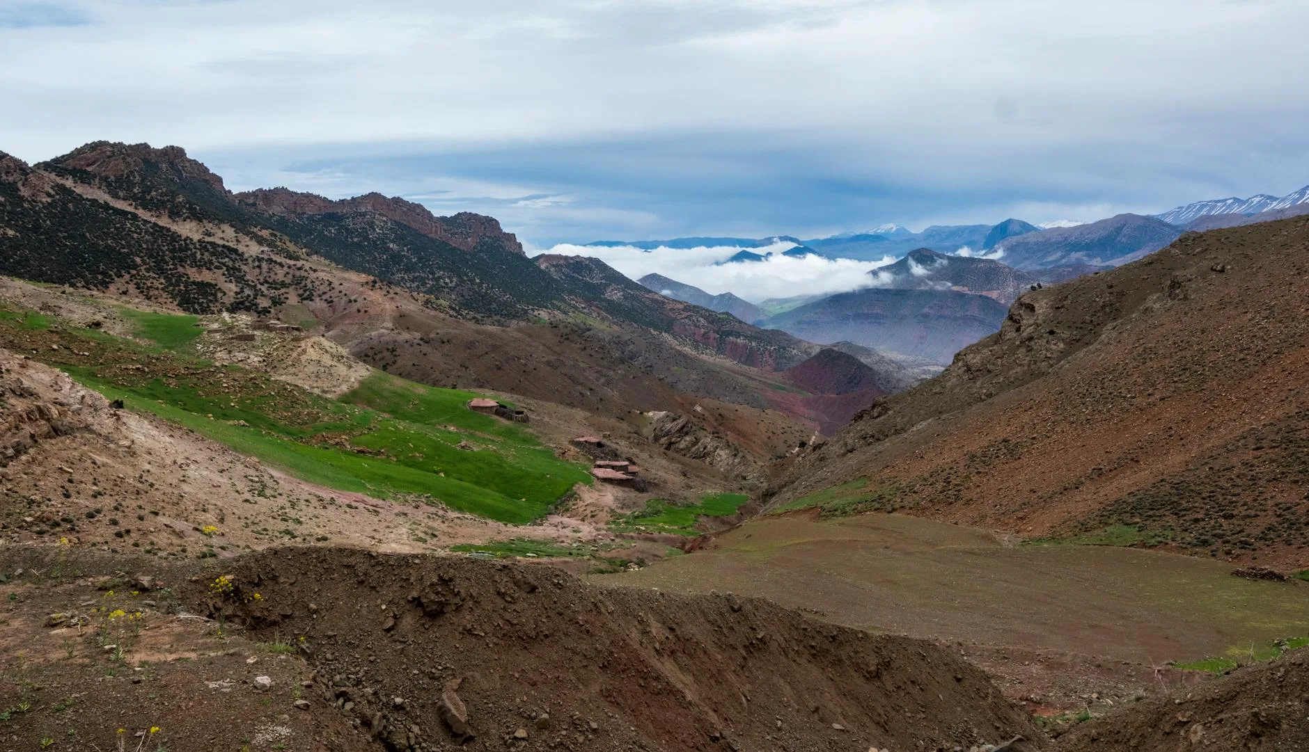
The mule track out of Imlil smells of dust, juniper and something faintly sweet — rose water from a guesthouse kitchen, maybe, or just the altitude doing something to your senses. By the time the village drops below you and the valley opens into its full corrugated width, Marrakech — with its noise, its heat, its relentless medina energy — feels like a different country. In a way, it is. The High Atlas is Berber territory, Amazigh-speaking, organised around irrigation channels and walnut groves rather than souks and riads.
This is the range that surprises first-time visitors most. Morocco’s mountains are serious: Jebel Toubkal, the highest peak in North Africa, sits at 4,167 metres. The trails that cross these ridgelines require preparation and respect, not just good intentions. But the Atlas also rewards hikers who have never gone above 3,000 metres, and its network of gîtes, mule tracks and village paths makes multi-day walking accessible without expedition-level kit.
This guide covers the main routes, realistic logistics, honest difficulty ratings and the practical information you need to plan a trip — whether you have three days or ten.
Understanding the range: High, Middle and Anti-Atlas
“The Atlas Mountains” covers a lot of ground. The range stretches roughly 2,500 kilometres from the Moroccan Atlantic coast to Tunisia, but for hikers, three sections matter:
The High Atlas runs northeast to southwest through central Morocco. This is where Toubkal sits, where most trekking infrastructure exists, and where you’ll find the most trail-tested routes. The Toubkal Circuit, the M’Goun traverse and the Aït Benhaddou area all fall here.
The Middle Atlas lies northeast of Marrakech, around the cedar forests near Azrou and Ifrane. Less dramatic than the High Atlas but genuinely beautiful — cedar woodland, Barbary macaques, quieter trails. A credible alternative if you want walking without the summit crowds.
The Anti-Atlas runs southwest toward Taroudant and Agadir. Older, more eroded, strikingly lunar. Jebel Sirwa (3,305m) sits here and offers one of Morocco’s finest multi-day treks — a loop through Berber villages with almost none of the Toubkal traffic.
Most first-time trekkers head to the High Atlas. That’s reasonable. But if timing allows for a second visit, the Anti-Atlas and Middle Atlas both earn their place on this list.
The Toubkal Circuit: what it actually involves
Jebel Toubkal is the obvious draw and the most organised route in the Atlas. The standard approach is a two-day ascent and descent via Imlil and the Toubkal Refuge (3,207m), with summit day covering about 1,300 metres of gain on loose scree — no technical climbing, but demanding.
Getting to Imlil: Shared taxis (grands taxis) run from Marrakech’s Bab Er-Rob taxi stand to Asni (45 minutes, around 20–25 MAD per seat). From Asni, another grand taxi covers the remaining 17 kilometres to Imlil (roughly 15–20 MAD). Total door-to-mountain: about 2 hours. Private transfers from Marrakech to Imlil run approximately 350–450 MAD and save the transfer hassle if you’re carrying a heavy pack.
Imlil itself is a small village with a dozen guesthouses, a few basic shops selling snacks and trail supplies, and a national park office where you pay the entry fee (currently around 20 MAD per person per day). Accommodation ranges from simple dormitories at around 120–150 MAD per night to gîtes with private rooms and half-board at 350–450 MAD.
The two-day Toubkal ascent:
– Day 1: Imlil to Toubkal Refuge, 3–4 hours, moderate-to-strenuous. The path follows the Mizane Valley through the village of Aroumd before climbing steadily.
– Day 2: Refuge to summit (2.5–3 hours up, 2 hours down), then descent to Imlil (3 hours). Total 9–11 hours on a long day, or split over three days if you want less pressure.
The Toubkal Refuge (CAF — Club Alpin Français) sleeps 70 people in dormitories. Meals are available. Book ahead in spring and autumn. Altitude sickness is real here — if you’ve come straight from sea level, consider spending a night at the refuge before summit day.
For a more extended circuit — 5 to 7 days — the Toubkal Circuit proper adds the valleys of Tacheddirt, Oukaïmeden and Lac d’Ifni, looping back to Imlil through high passes (tizi) above 3,400 metres. This route passes through half a dozen villages and involves one or two demanding ridge crossings. A guide is not legally required, but navigation on some sections is genuinely unclear, especially in cloud.
The M’Goun Traverse: the Atlas without the summit crowds
If Toubkal is Morocco’s most-climbed mountain, the M’Goun Massif is its most rewarding multi-day trek. The standard traverse runs from Aït Benhaddou (or Kelaat M’Gouna in the Dadès Valley) over the 4,071-metre summit of Jebel M’Goun to the Ahansal Valley and then down to Azilal — roughly 7 to 10 days depending on pace and variant.
The route crosses the southern High Atlas, which means you’re walking through landscapes that shift dramatically: dry scrub and pink kasbahs in the Dadès, green pastures and walnut groves as you gain altitude, then stark talus fields near the summit and lush canyon country on the northern descent toward Ahansal. Very few stretches overlap with Toubkal traffic.
This is a genuine wilderness route. There are no refuges — nights are spent in village gîtes or camping. Donkeys or mules are typically hired to carry camping gear and food supplies, arranged through the trek’s starting village. A guide is strongly advisable on the M’Goun traverse, not because the terrain is technical but because route-finding across the plateau sections is unreliable, and the villages along the way have limited provisions.
Logistics: Buses run from Marrakech to Kelaat M’Gouna (6–7 hours, CTM and Supratours both serve the route, around 90–120 MAD). Ouarzazate is an alternative hub — well connected by bus and with a small airport. For the northern end of the traverse, Azilal is reachable from Beni Mellal by grand taxi.
Jebel Sirwa: the Anti-Atlas alternative
Sirwa doesn’t get much coverage in English-language guides, which is partly why it’s worth including here. The standard circuit — a 7-day loop out of Taliouine, a small town on the N10 between Taroudant and Ouarzazate — crosses several passes above 2,500 metres and passes through villages where saffron is grown at altitude. Morocco produces some of the world’s best saffron, and the area around Taliouine and Assaiss is the centre of it.
The walking itself is less dramatic than the High Atlas — no glaciated cirques, no scree summits — but the landscapes are older and stranger: eroded sandstone ridges, acacia scrub, wide skies. Gîte infrastructure exists but is simpler than the Toubkal area. Most trekkers arrive via Taroudant (buses from Agadir, 2–3 hours, around 50–70 MAD) and then grand taxi to Taliouine.
When to go: a practical seasonal breakdown
Timing matters more in the Atlas than in many mountain ranges. The altitude swings are significant, and winter routes are a different proposition entirely.
| Season | Conditions | Best For | Avoid If |
|---|---|---|---|
| March–May | Snow melting on high passes, wildflowers, moderate temps | Most routes; ideal for Toubkal Circuit | You dislike mud and unpredictable passes above 3,200m |
| June–early July | Clear, warm, trails dry | All routes including M’Goun; best overall window | You’re heat-sensitive at lower elevations |
| July–August | Hot below 2,000m, thunderstorms possible at altitude | High camps only; not ideal | You’re planning valley walks; heat is punishing |
| September–October | Excellent — clear skies, cooler temps, harvest season | All routes; arguably the best month is October | You’re on a tight schedule (weather can shift fast in Oct) |
| November–February | Snow above 2,500m; Toubkal summit requires crampons and ice axe | Sirwa, Middle Atlas, village walks | Summit Toubkal unless you have winter mountaineering experience |
For guidance on planning high-altitude treks elsewhere in the world, the approach to trekking in Nepal — permits, teahouse logistics, seasonal timing — offers useful comparison points.
Guides, gîtes and what you’ll actually pay
Guides: Licensed mountain guides in Morocco are registered with the Ministry of Tourism and distinguishable from unlicensed touts by their official ID cards. In Imlil, you’ll be approached by both. A licensed guide for a full Toubkal ascent runs approximately 600–800 MAD per day (roughly €55–75). For the M’Goun traverse, expect 700–900 MAD per day plus mule hire (around 200–300 MAD per mule per day). The guide to finding a good local guide without an agency covers how to vet credentials and agree on terms without getting locked into overpriced packages.
Gîtes: Gîte accommodation throughout the Atlas runs 100–200 MAD per night for a dormitory bed, or 300–450 MAD with half-board (dinner and breakfast). Meals lean heavily on tagine, harira (a thick lentil and tomato soup), and khobz (flatbread). In the high villages, fresh produce is whatever comes from the village itself — don’t expect a menu.
Budget estimate for a 5-day Toubkal Circuit:
– Transport Marrakech–Imlil return: 100–150 MAD
– National park fees: 100 MAD (5 days)
– Accommodation and meals (half-board gîtes): 1,500–2,000 MAD
– Guide (optional on the shorter routes, recommended on the circuit): 3,000–4,000 MAD
– Toubkal Refuge (1 night): 150–200 MAD
– Total with guide: approximately 5,000–6,500 MAD (€460–600)
– Total without guide: approximately 2,000–2,500 MAD (€185–230)
Berber villages, food and cultural context
The villages along the Atlas routes — Aroumd, Tacheddirt, Ait Aissa, Aït Tamsoult — are working agricultural settlements, not set-dressing for trekkers. The Amazigh (Berber) population here has lived by transhumance — moving livestock between valley pastures in winter and high meadows in summer — for centuries. You’re passing through those landscapes.
Basic Tamazight phrases are appreciated: azul (hello), tanmirt (thank you). French works throughout; Darija (Moroccan Arabic) is understood; English is common in Imlil, patchier in higher villages.
Food in the gîtes runs a tight rotation: vegetable tagine in the evening, bread and amlou (an almond, argan and honey paste) at breakfast. In Imlil’s cafés, you can get better harira and bessara (fava bean soup with cumin and olive oil) for 25–40 MAD a bowl. This isn’t a region for culinary experimentation — it’s honest mountain food, and it’s filling.
If you’re pairing an Atlas trek with time in Marrakech’s medina, the Morocco Medina Life Beyond the Tourist Trail piece covers what’s worth seeing there, and what isn’t.
The National Geographic overview of Morocco’s mountains and the UK Foreign, Commonwealth & Development Office travel advisory for Morocco both carry current, reliable information on access and safety.
What to pack: honest essentials
The Atlas is not a place to improvise your kit. Nights above 3,000 metres drop below freezing even in summer. Afternoon cloud can reduce visibility on ridge routes. The scree above Toubkal Refuge shreds soft-soled shoes.
- Boots: Stiff-soled hiking boots, not trail runners. The descent from Toubkal is ankle-punishing on soft footwear.
- Layers: Down jacket, windproof shell, thermal base layer. Even in June, night temperatures at the refuge are 2–5°C.
- Water: Carry 2–3 litres capacity. Iodine tablets or a filter for stream water above tree line.
- Sun protection: At altitude, UV intensity is higher than it feels. SPF 50 and sunglasses are not optional.
- Cash: There are no ATMs above Imlil. Bring enough MAD from Marrakech.
- First aid: Altitude medication (acetazolamide / Diamox) is available by prescription in Morocco and advisable if you’re ascending quickly. A basic kit with blister treatment, rehydration salts and ibuprofen covers most eventualities.
The Bottom Line
-
Match the route to your fitness level and timeline. The two-day Toubkal ascent is achievable for most hikers with reasonable fitness. The M’Goun traverse and Sirwa Circuit require a week minimum and are better suited to those comfortable with remote, multi-day walks.
-
Go in spring or autumn. April–May and September–October offer the clearest conditions, manageable temperatures and full access to high passes. Summer works but is hot at low elevations; winter requires genuine mountaineering experience for anything above 3,000 metres.
-
Hire a licensed guide for the circuit routes. On the standard Toubkal ascent, the path is clear. On the Toubkal Circuit, M’Goun traverse or Sirwa loop, local knowledge is worth the cost — not for hand-holding, but for navigation, logistics and village-to-village food and accommodation arrangements.
-
Budget in MAD, not hotel-room logic. The Atlas is inexpensive at gîte level — a well-fed, well-walked week need not cost more than €300–400 without a guide, €600–700 with one. The costs that catch people out are private transfers and overpriced “private guides” arranged through Marrakech riads at double the local rate.
-
The mountains are the point, but the villages are the texture. Spending an extra afternoon in Tacheddirt or Aroumd — watching irrigation water get distributed among family plots, sitting with tea in a gîte courtyard — adds more to the trip than an extra summit. Build slack into the itinerary.
Keep reading: Morocco Medina Life Beyond the Tourist Trail